
Italy Trentino (3 map set) Kompass map 683 hiking, cycling skiing
Specifications
| Return Postage Will Be Paid By | Buyer |
| Returns Accepted | Returns Accepted |
| After Receiving The Item, Your Buyer Should Cancel The Purchase Within | 30 days |
| Author | Kompass |
| Publication Name | Trentino |
| Type | Hiking Map |
| Publisher | Kompass |
| Series | Kompass Hiking Maps |
| Country | Italy |
| Publication Year | 29 June 2021 |
| Region | Europe |
| Format | Folding Map |
| Map Scale | 1:50,000 |
| Country/Region Of Manufacture | Germany |
| Item Weight | 0.251kg |
| MPN | Does not apply |
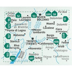
eBay Store Design by Visualsoft Italy Trentino (3 map set) Kompass map 683 hiking, cycling skiing £16.99 | The province of Trentino stretches from the Tonale Pass in the west to the Pala Group near San Martino di Castrozza in the east and is covered by this set of three hiking/cycling maps Its north-south extent stretches from Canazei in the north and to Lake Garda in the south. The eastern Trentino region is characterised by individual limestone massifs such as Pala and Sella Group, Latemar Rosengarten, Marmolata and Langkofel Group. This is followed in the south by the Lagorai mountain range, between the Fleimstal valley in the north and Passo Rolle in the south. To the western Trentino belong well-known mountain groups like the Adamello-Presanella massif between Ortler and Lake Garda with three thousand meter peaks like Cima Presanella (3556 m) and Monte Adamello (3554 m) as well as the Brenta Dolomites, the only Dolomite group west of the Adige, with their jagged towers and peaks (highest elevation Cima Tosa). Madonna di Campiglio and Molveno are the most well-known starting points for the central Dolomites. The most important towns and villages are Trento, Rovereto, Madonna di Campiglio, Riva; the most famous lakes are Lake Garda, Lake Ledro, Lake Idro, Lake Molveno. The light blue Lake Molveno, the Vajolet Towers in the Rosengarten, the Via Ferrata of the Brenta, the "Sentiero della Pace" in the Adamello massif, a stroll through the city of Trento, a hike in the Lagorai group, in the Val di Fassa or on the Piz Boe at Passo Pordoi - all this is in the Trentino region. Ask a Question Description About the Hiking maps series: Shows all hiking and biking trails with difficulty level, important tourist information. Ski paths are shown in mountainous regions Map legend is in German, Italian and English GPS compatible At a scale of 1:25.000/1:35.000 or 1:50.000 Tear and weatherproof paper eBay Store Design by Visualsoft
Related Items