


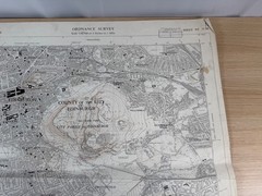


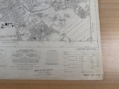


Ordnance Survey Map Edinburgh 1955 Sheet NT 27 SE 6″ 1:10560 Holyrood Vintage
USD 40.34 USD
Specifications
| Publication Name | Ordnance Survey |
| Publisher | Ordnance Survey |
| City | Edinburgh |
| Subject | Geography & Geosciences |
| Series | Ordnance Survey |
| Publication Year | 1955 |
| Type | Ordnance Survey Map |
| Format | Wall Map |
| Language | English |
| Region | Great Britain |
| Features | Folding Map |
| Map Scale | 1:10,560 |
| Country Of Origin | United Kingdom |
The sheet covers the south-east quadrant of Edinburgh and includes a remarkable cross-section of the city's most famous landscape. Holyrood Park, Arthur's Seat and Salisbury Crags dominate the centre, beautifully rendered with detailed contours at 25-foot vertical intervals.
Related Items

Hilversum ‘t Gooi (Map)

Lonely Planet Southwest USA Planning Map, Paperback by Balfour, Amy C., Brand…

Ordnance Survey One-Inch Map, Sheet 150: Ipswich (1969).

BARTHOLOMEW Half Inch Cloth Maps x7 Wales Trent Solway Clyde Ayrshire Islay Skye

North Dartmoor & Mid Devon 1887 One Inch Sheet 324 by Tom Greeves
Bromsgrove 1926 Worcestershire Sheet 15.16 by Malcolm Nixon

Russia / Georgia Caucasus Central: Mt Elbrus to Mt Kazbek Map and Guide

Movie Star Homes: The Famous to the Forgotten