


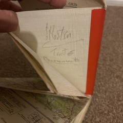
1940s Vintage OS Map Aldershot Sheet 169 Cloth Backed Hampshire Surrey
USD 10.76 USD
Specifications
| Publication Year | 1940 |
| Publication Name | New Popular Edition |
| Publisher | Ordnance Survey |
| City | Aldershot |
| Subject | Maps |
| Series | New Popular Edition |
| Type | Hiking Map |
| Format | Folded Map |
| Language | English |
| Author | Ordnance Survey |
| Country | United Kingdom |
| Region | Great Britain |
| Features | Folding Map |
| Country Of Origin | United Kingdom |
First published 1940 with full revision of 1930 and roads revised to 1947 with later corrections. Cloth edition, originally sold at five shillings. Covers Aldershot and surrounding areas including Farnborough, Fleet, Farnham, Guildford, Woking, Sandhurst, Ascot, Alton and Haslemere. A desirable military and local history map from the post-war period, ideal for collectors, historians, walkers and cartography enthusiasts. Vintage used condition. Cover shows age related wear, creasing and edge wear. Map appears complete and remains in good readable condition. Please study all photographs carefully as they form part of the description. Cloth backing has a small pencil ownership annotation and light age related wear.
Related Items

Ruislip (SE) 1940 Middlesex Sheet 10.14 by Peter Hounsell

c1907 Harmsworth Plate No. 203-204 Queensland

AA 50TH YEAR ANNIVERSARY ATLAS IN VERY GOOD CONDITION

National Geographic Concise Atlas of the World, 4th Edition (2016, Trade PB)

OS,Ordnance Survey, Explorer map Sheet 132, Winchester, New Alresford

Freytag-Berndt Europe political, 1:6 million, Flat in tube (Map) (UK IMPORT)

Ordnance Survey One Inch Tourist Map – North York Moors – 1982

17″ x 22″ Rand McNally Markable Map of Europe and Outline Two-Sided Pre-owned