Have you ever wondered how maps accurately represent our world or how navigation systems guide us with precision? The answer lies in a concept called coordinate systems. While it may sound daunting, coordinate systems are fundamental tools that enable us to make sense of spatial data and ensure accurate representations. In this article, we will demystify coordinate systems, explaining their purpose and significance, particularly in the context of Geographic Information Systems (GIS) like yey’maps. We will also explore the consequences of working with incorrect coordinate systems and how they can affect geometries and distances.
At its core, a coordinate system is a reference framework that assigns unique numerical values to specific points in space. It provides a standardized language for representing and understanding spatial locations. Imagine a giant grid overlaid on the Earth’s surface. Coordinate systems establish rules and guidelines to identify the position of any point within that grid, allowing us to communicate and analyze spatial data accurately.
But why do we need coordinate systems? The primary reason is to ensure consistency and interoperability among different maps, data sources, and GIS applications. Without a standardized coordinate system, it would be nearly impossible to combine and analyze spatial data from various sources effectively. Let’s delve into the importance of using the correct coordinate system through a few examples:
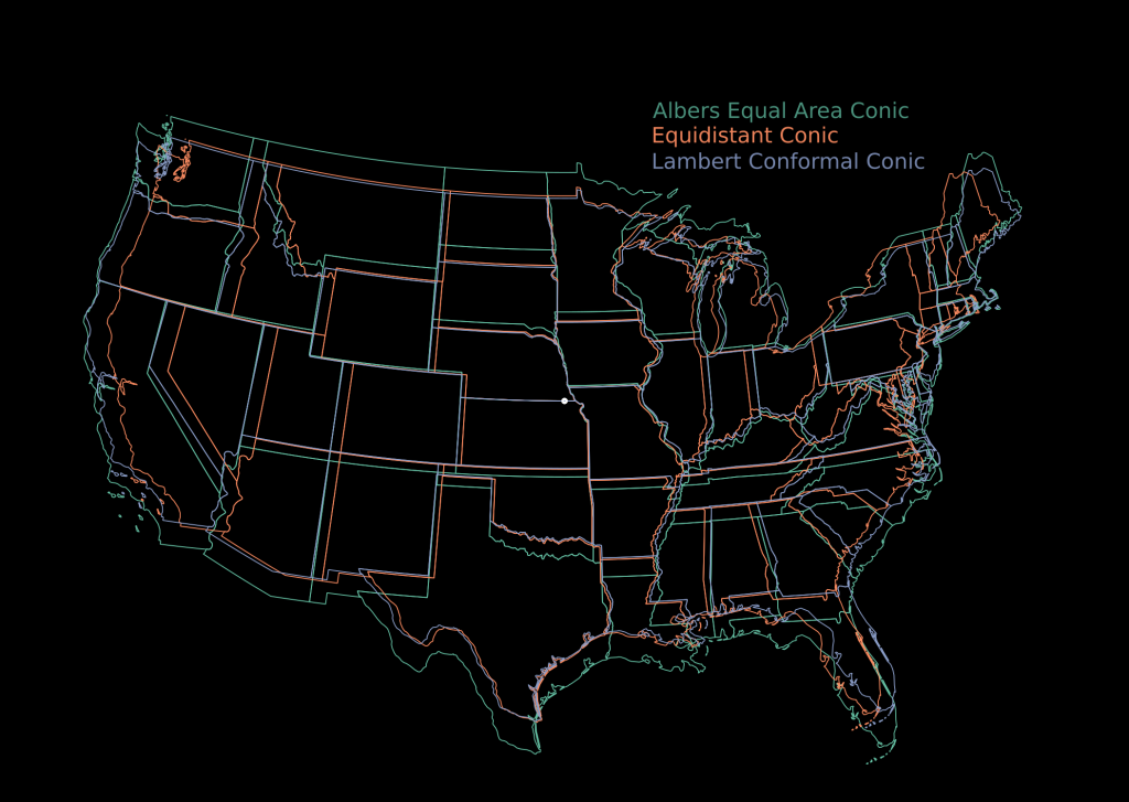
Distortions in Map Projections:
Maps are two-dimensional representations of our three-dimensional Earth, and projecting a curved surface onto a flat map inherently introduces distortions. Different map projections attempt to minimize these distortions based on specific use cases. For instance, the Mercator projection preserves angles and shapes but distorts areas. The Robinson projection balances shape and size but sacrifices accuracy. When working with yey’maps, using the appropriate coordinate system based on the map projection ensures that spatial data maintains accurate shapes, sizes, and distances.
Warping of Geometries:
Geometries, such as points, lines, and polygons, are essential components of spatial data. Each geometry has specific coordinates that define its shape and location. When a geometry is represented using an incorrect coordinate system, it can lead to warping and misalignment. For example, if you overlay a polygon on a map without considering the coordinate system, it may appear distorted or misplaced. The correct coordinate system aligns geometries accurately, ensuring spatial data integrity

Offset Distances:
Distance measurements are fundamental in GIS applications, aiding in navigation, spatial analysis, and planning. However, using an inappropriate coordinate system can introduce distance offsets. For instance, if you calculate the distance between two points in a map using a coordinate system not suited for that region, the result may be inaccurate. This discrepancy becomes more pronounced over larger distances. The correct coordinate system ensures that distance calculations reflect the actual physical distances on the ground, enabling accurate measurements.
Projection Matching:
In GIS projects that involve combining multiple spatial datasets, it is crucial to ensure that all datasets share the same coordinate system. If datasets with different coordinate systems are combined without proper alignment, inconsistencies arise. For example, overlaying a river dataset on a road network dataset without matching the coordinate systems can lead to misalignment and errors. Coordinate system matching or conversion is necessary to integrate and analyze spatial data seamlessly.